
Overview
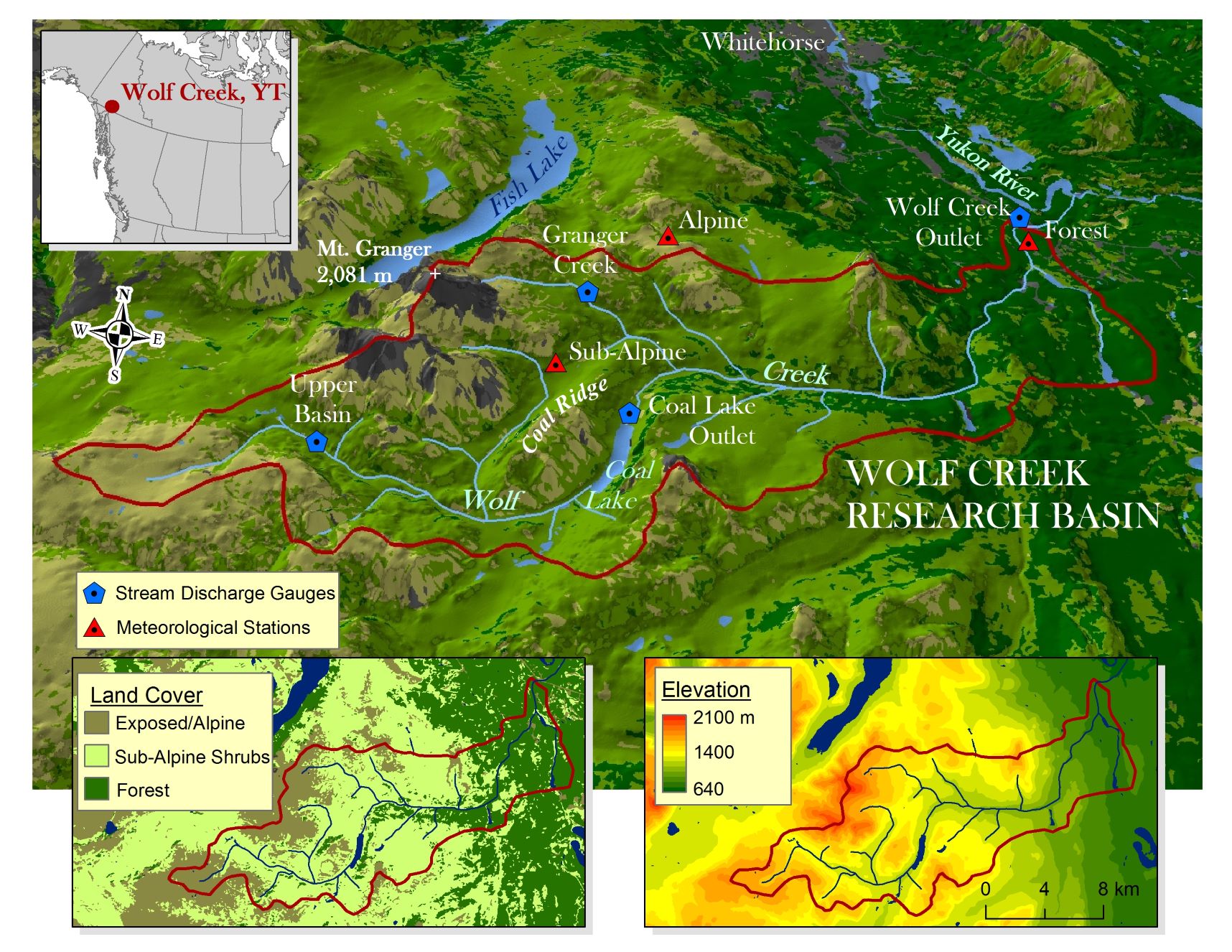
- Location: Yukon Territory, Canada; 60.52°N, 135.13°W
- Website: http://www.wolfcreekresearchbasin.ca/
- Operational Management: McMaster Watershed Hydrology Group, McMaster University; Water Resources Branch, Yukon Environment; Centre for Hydrology, University of Saskatchewan
- Purpose/Scientific Focus: Wolf Creek Research Basin (WCRB) is located on the traditional territory of the Kwanlin Dün First Nation, Ta’an Kwäch’än Council and Carcross/Tagish First Nation. In 1992, the WCRB was established in the sub-Arctic mountainous headwaters of the Yukon River, near Whitehorse, Yukon, Canada and is representative of many headwater basins along the far northern reaches of the North American Cordillera. WCRB was established to provide science-based evidence for decision-making in the across of water, climate and the biosphere and to provide a test-bed to help resolve deficiencies in hydrological models in cold climates. The foundation of research in WCRB is to improve the understanding of cold region hydrological processes and their interaction with climate and vegetation and to better represent this understanding through improved conceptualization and parametrization of numerical hydrological and related models.
Characteristics
- Location (Physiographic Region): WCRB is a subarctic headwater basin, situated within the Watson Highlands Boreal Cordillera Ecological Region of North America, with a long and cold snow season characterized by low precipitation.
- Area: 179 km2
- Elevation: Min. 660 m to max. 2080 m
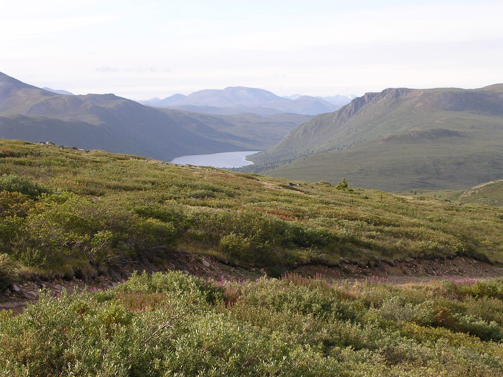
- Description (Physical–Ecological–Climatic Characteristics): Mountainous landscape with a complex geology and glacial history, and thick till deposits. Sporadic permafrost at high elevations and north-facing slopes (~30% of WCRB). Cold subarctic climate; conditions are somewhat continental as the basin is situated leeward of higher, glaciated mountains in coastal B.C. and Alaska. Distinct ecological biomes include alpine tundra, shrub tundra and taiga, and boreal forest.
- Drainage/River System: Located near Whitehorse, Yukon within the Upper Yukon River Basin; representative of much of the interior Subarctic Cordilleran landscape..
- Site History/Historical Context: Initiated as a long-term multidisciplinary research project in 1992. See “History of WCRB”: http://www.wolfcreekresearchbasin.ca/history.html.
- Main Land Cover(s): Dense Boreal Forest at lower elevations, sparse forest, open meadow and shrub tundra at the higher elevations, and exposed alpine areas with mostly bare rock at the highest elevations..
- Lithology/Soils: Primarily sedimentary rocks capped by a mantle of till at least 2 m thick, as well as glaciofluvial and glaciolacustrine deposits. Well drained soils with coarse parent materials. Lower elevation forest soils are clay to gravel texture, while upland soils are sandy loam to gravely sandy loam texture. Surface organics commonly extend to depths of 0.1 m and are deepest in riparian areas and north-facing slopes.
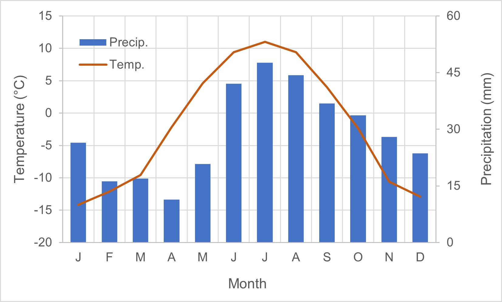
- Mean Annual Temperature: −2.1°C
- Mean Total Annual Precipitation: 350 mm
- Snow Characteristics: Above treeline, snow is highly redistributed due to wind and blowing snow—deep drifts form on leeward slopes and in sheltered terrain. Snow or hoarfrost can frequently build up on sensors in midwinter. Seasonal, dry snow, lots of depth hoar, high density in alpine. Snowmelt dominated runoff with peak flows in late May or early June and low flows in March.
- Years of Data: 1993 – present
Stations & Observations
Observational Stations and Sites
| Type | Station Name | Latitude | Longitude | Elevation | Notes/Details |
| Meteorological | Shrub Tundra–Taiga Station (Buckbrush) | 60.522°N | 135.197°W | 1250 m | East-facing moderate slope |
| Meteorological | Alpine Tundra Station (Alpine) | 60.567°N | 135.150°W | 1615 m | Windswept ridge top plateau |
| Meteorological | White Spruce Forest Station (Forest) | 60.596°N | 134.953°W | 750 m | Gently undulating terrain |
| Meteorological | Whitehorse WSO | 60.733°N | 135.083°W | 706 m | At Environment Canada site |
| Hydrometric | Upper Wolf Creek | 60.491°N | 135.292°W | 1295 m | Drainage area: 14.4 km2 |
| Hydrometric | Coal Lake Outlet | 60.510°N | 135.162°W | 1190 m | Drainage area: 70.5 km2 |
| Hydrometric | Granger Creek | 60.546°N | 135.185°W | 1312 m | Drainage area: 7.6 km2 |
| Hydrometric | Alaska Highway | 60.600°N | 134.950°W | 703 m | Drainage area: 179 km2 |
| Groundwater Well | Wolf Creek Well | 60.574°N | 134.962°W | 750 m | Water level and temperatures |
|
Notes Real-time conditions and historical data for meteorological, stream-flow, and soil measurement stations at DCEW can be accessed via the links at https://www.boisestate.edu/drycreek/dry-creek-data/. |
|||||
Field Observation Campaigns and Other Measurements
| Measurement | Instrument Description | Spatial/Temporal Resolution and Coverage | Notes/Details |
| Terrestrial Laser Scanner | N/A | ||
| UAV Sensors | DJI Mavic, eBee | ||
| Time-lapse Photographs | Daily | Above canopy at Forest station | |
| Snow Pits/Snow Surveys | Snow depth rod and Mt. Rose sampler | 1993 – present; Monthly; surveys near Alpine, Buckbrush, Forest stations | Each has a 25 point transect for snow depth. Snow density measured at 5 out of 25 points. Relationship between snow depth and density used to estimate density across the transect; measured and estimated snow density used to estimate SWE. |
|
Notes At many times over the history of WCRB there have special, focused field campaigns and intensive observations (e.g., detailed and repeated snow surveys, snow pits, vegetation and soil moisture surveys, permafrost and active layer depth surveys, hydrological investigations on flow pathways and runoff responses, turbulent fluxes, blowing snow and snow redistribution, and more). These have mostly been conducted within the Granger Creek sub-basin and nearby parts of the WCRN. Data are archived with the McMaster Watershed Hydrology Group and University of Saskatchewan Centre for Hydrology. |
|||
Data Availability
Geospatial Data
| Elevation |
Digital elevation model (DEM) with 30 m resolution—available from and described by Rasouli et al. (2019) https://doi.org/10.5194/essd-11-89-2019. Updated LiDAR from August 2018. Flown by Brian Menounos. Not published. Point density of 12/m2. |
| Landcover and Soils |
Landcover types in Wolf Creek Research Basin—Raster file available from and described by Rasouli et al. (2019) https://doi.org/10.5194/essd-11-89-2019. Updated by Landsat 7 and 8; LiDAR |
| Stream/River Network | Location of the streams; Location of the lakes—Shapefiles available from and described by Rasouli et al. (2019) https://doi.org/10.5194/essd-11-89-2019 |
| Basin Delineation/Shapefile | Boundary of Wolf Creek Research Basin—Shapefile available from and described by Rasouli et al. (2019) https://doi.org/10.5194/essd-11-89-2019 |
Observational Data Availability
- Rasouli, K., Pomeroy, J. W., Janowicz, J. R., Williams, T. J., and Carey, S. K.: A long-term hydrometeorological dataset (1993–2014) of a northern mountain basin: Wolf Creek Research Basin, Yukon Territory, Canada, Earth Syst. Sci. Data, 11, 89–100, https://doi.org/10.5194/essd-11-89-2019, 2019.
- Wolf Creek Research Basin Realtime and Historical Data: http://www.wolfcreekresearchbasin.ca/data.html
Modelling Activities

WCRB has been a testbed for many cold regions hydrological modelling developments and applications over the past three decades. In particular, the Cold Regions Hydrological Modelling (CRHM) platform (see https://doi.org/10.1016/j.jhydrol.2022.128711) has been advanced by work at WCRB to improve representation of snow–shrub interactions, forest canopy snow interception, blowing snow, snowmelt and infiltration to frozen soils, and runoff generation (https://research-groups.usask.ca/hydrology/documents/pubs/papers/pomeroy_et_al_2010.pdf).
Contact & Further Information
-
The WCRB website (http://www.wolfcreekresearchbasin.ca/) contains many relevant details, including history, publications, current projects, maps and photographs, and more. As part of the Changing Cold Regions Network (www.ccrnetwork.ca), an information brochure was developed, explaining the changes that are taking place here and describing the basin and the research: https://ccrnetwork.ca/documents/wolf_creek_changes.pdf.
See also Wolf Creek 25 year science summit (https://ccrnetwork.ca/science-programme/workshops/2017-wolf-creek-science-summit.php) and hear about the 30 year anniversary celebration in 2022 (https://www.cbc.ca/player/play/2058405955736).
Follow on Twitter: https://twitter.com/WolfCreekYT
- Dr. Sean Carey, Professor and Director of Watershed Hydrology Group, McMaster University, Hamilton, ON, Canada. (careysk@mcmaster.ca)