
Overview
- Location: Italy; 45.84°N, 7.58°E
- Operational Management: Environmental Protection Agency of Aosta Valley, Italy
- Purpose/Scientific Focus: Torgnon Basin is located in Aosta Valley, on the Italian side of the European Alps. It consists mainly of two observational sites located in an alpine grassland and a larch (Larix decidua) forest. Sites were established in 2008 as long term ecological research sites to provide science-based evidence for decision-making on climate change impacts, water management, biosphere and carbon cycle. Collected observations and ancillary data have been used as test-bed to help resolve deficiencies in hydrological, snow, ecological and carbon cycle models in the mountains.
Characteristics
- Location (Physiographic Region): North-Western Eurpoean Alps.
- Area: ~20 km2
- Elevation: Min. 1,800 m to Max. 3,200 m
- Description (Physical–Ecological–Climatic Characteristics): Mountainous landscape with a complex geology and glacial history, and thick till deposits. Sporadic permafrost at high elevations and north-facing slopes (~5% of the basin). Alpine climate; conditions are somewhat continental (low precipitation in summer) as the basin is situated close to the east-west axis of the main valley. Distinct ecological biomes include alpine vegetation, meadows and grasslands and coniferous forests.
- Drainage/River System: Main stream (Petit Monde) within the Dora Baltea River Basin, part of the Po River system.
- Site History/Historical Context: Initiated as a long-term multidisciplinary research project in 2008.
- Glacierized Area (% and year(s) measured): No glaciers, but some small perennial snow drifts on leeward slopes at high elevations.
- Main Land Cover(s): Coniferous forests, grasslands, open meadow and shrub tundra at the higher elevations, and exposed alpine areas with mostly bare rock at the highest elevations.
- Lithology/Soils: Primarily metamorphic acidic rocks capped by a mantle of till on average 0.5-2 m thick, as well as glaciofluvial and glaciolacustrine deposits. Well drained soils with coarse parent materials. Surface organics commonly extend to depths of 0.3 m. Main soil types: podzol, cambisol, inceptisol.
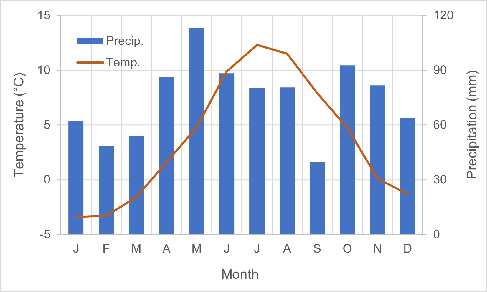
- Mean Annual Temperature: 3.66°C
- Mean Total Annual Precipitation: 891.5 mm
- Snow Characteristics: Above treeline, snow is highly redistributed due to wind and blowing snow—deep drifts form on leeward slopes and in sheltered terrain. Seasonal, dry snow, high density in late winter (Apr-May). Frequent dust depositions. Snowmelt dominated runoff with peak flows in late May or early June and low flows in Jan-Feb.
- Accesibility: Road access by truck/ATV in summer and snowmobile in winter. Nearby accommodation available. Major airport at ~150 Km (Milan, Turin)
- Years of Data: 2008 to present
Stations & Observations
Observational Stations and Sites
| Type | Station Name | Latitude | Longitude | Elevation | Notes/Details |
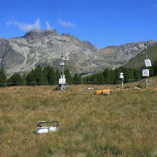
| Meteorological | IT-Tor | 45.8444°N | 7.5781°E | 2160 m | Grassland |
| Meteorological | IT-Trf | 45.8238°N | 7.5609°E | 2150 m | Eurpoean Larch forest |
Field Observation Campaigns and Other Measurements
| Measurement | Instrument Description | Spatial/Temporal Resolution and Coverage | Notes/Details |
| Terrestrial Laser Scanner | |||
| UAV Sensors |
senseFly eBee X; DJI Matrice 300; DJI Phantom 4 PRO, RTK and MS; Mavic Dual; Mavic 3 Pro; Matrice 210 V2 RTK; Inspire 2 |
yearly |
|
| Time-lapse Photographs | phenocam | daily | IT-Tor, IT-Trf; https://phenocam.nau.edu/webcam/sites/torgnon-nd/ & https://phenocam.nau.edu/webcam/sites/torgnon-ld/ |
| Snow Pits/Snow Surveys | Snow pits and snow density @IT-Tor and IT-Trf | Approximately 2-3 per snow season | |
Data Availability
Geospatial Data
| Elevation | Digital elevation model (DEM) with 10 m resolution (2008) |
| Landcover and Soils |
Landcover and soil types available from regional cartography portal https://geoportale.regione.vda.it/ |
| Stream/River Network | Location of the streams; Location of the lakes—Shapefiles available upon request to PI |
| Basin Delineation/Shapefile | Boundary of Torgnon Basin—Shapefile available upon request to PI |
Observational Data Availability
Modelling Activities
Torgnon site has been a testbed for many alpine snow hydrological and ecohydrological modelling developments and applications over the past two decades.
- snow model reanalysis: https://essd.copernicus.org/articles/15/639/2023/essd-15-639-2023-discussion.html
- snow model development: https://gmd.copernicus.org/articles/15/4853/2022/
- Snow model intercomparison: https://hess.copernicus.org/articles/24/4061/2020/
- snow thermal inertia: https://agupubs.onlinelibrary.wiley.com/doi/full/10.1029/2019GL082193
- role of dust on snowmelt: https://tc.copernicus.org/articles/13/1147/2019/
- evapotranspiration: https://agupubs.onlinelibrary.wiley.com/doi/full/10.1029/2019WR026058
Contact & Further Information
Further Information
- https://www.icos-italy.it/wp-content/uploads/2021/03/torgnon.pdf
- https://specnet.info/italy-torgnon/
Contacts
- Marta Galvagno, Environmental Protection Agency of Aosta Valley, ARPA VdA, Climate Change Unit, Aosta, Italy, (m.galvagno@arpa.vda.it)
- Palo Pogliotti, (p.pogliotti@arpa.vda.it)
- Umberto Morra di Cella, Environmental Protection Agency of Aosta Valley, ARPA VdA, Climate Change Unit, Aosta, Italy, (u.morradicella@arpa.vda.it)
- Francesco Avanzi, CIMA Research Foundation, Via Armando Magliotto 2, 17100 Savona, Italy (francesco.avanzi@cimafoundation.org)
- Edoardo Cremonese, Environmental Protection Agency of Aosta Valley, ARPA VdA, Climate Change Unit, Aosta, Italy, (edoardo.cremonese@cimafoundation.org)