Overview

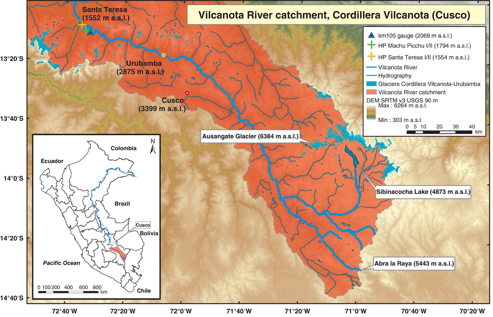
- Location: Cuco, Peru; 14.1°S, 71.0°W
- Operational Management: Universidad Nacional de San Antonio Abad del Cusco; SENAHMI; Imperial College London / British Geological Survey / University of Birmingham
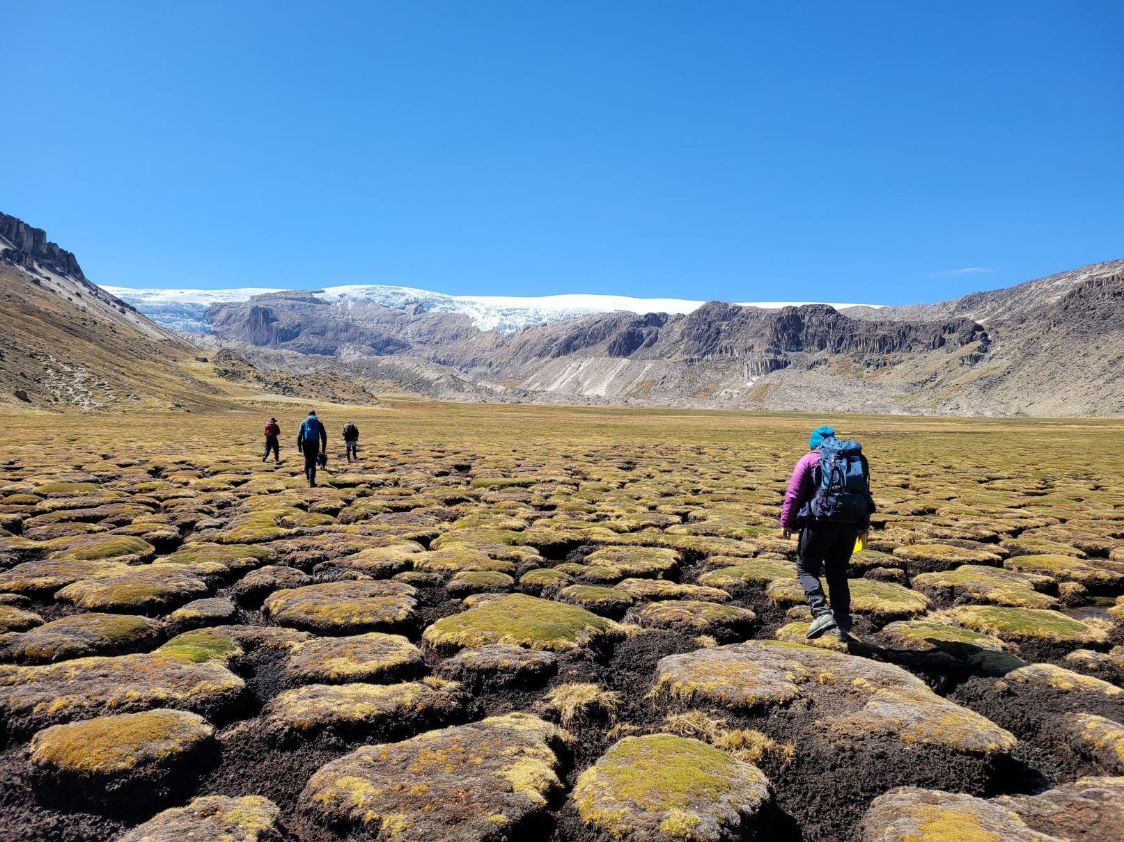
- Purpose/Scientific Focus: Monitoring focused mainly on a small headwater catchment within the wider basin (the glacierized Suyaparina-Quisoquipina catchment), for which basic hydrometric monitoring has been ongoing since 2016. More extensive monitoring has been ongoing since 2021, and the site is the focus of studies exploring the hydrological functioning of high-altitude wetlands, known locally as bofedales, and used extensively by local pastoralists for livestock grazing.
Characteristics

- Location (Physiographic Region): High-plateau Antiplano region in the Eastern Cordillera of Southern Peru.
- Area: 1155 km2 (SQC headwater basin = 53.6 km2)
- Elevation: 3500-6000 m
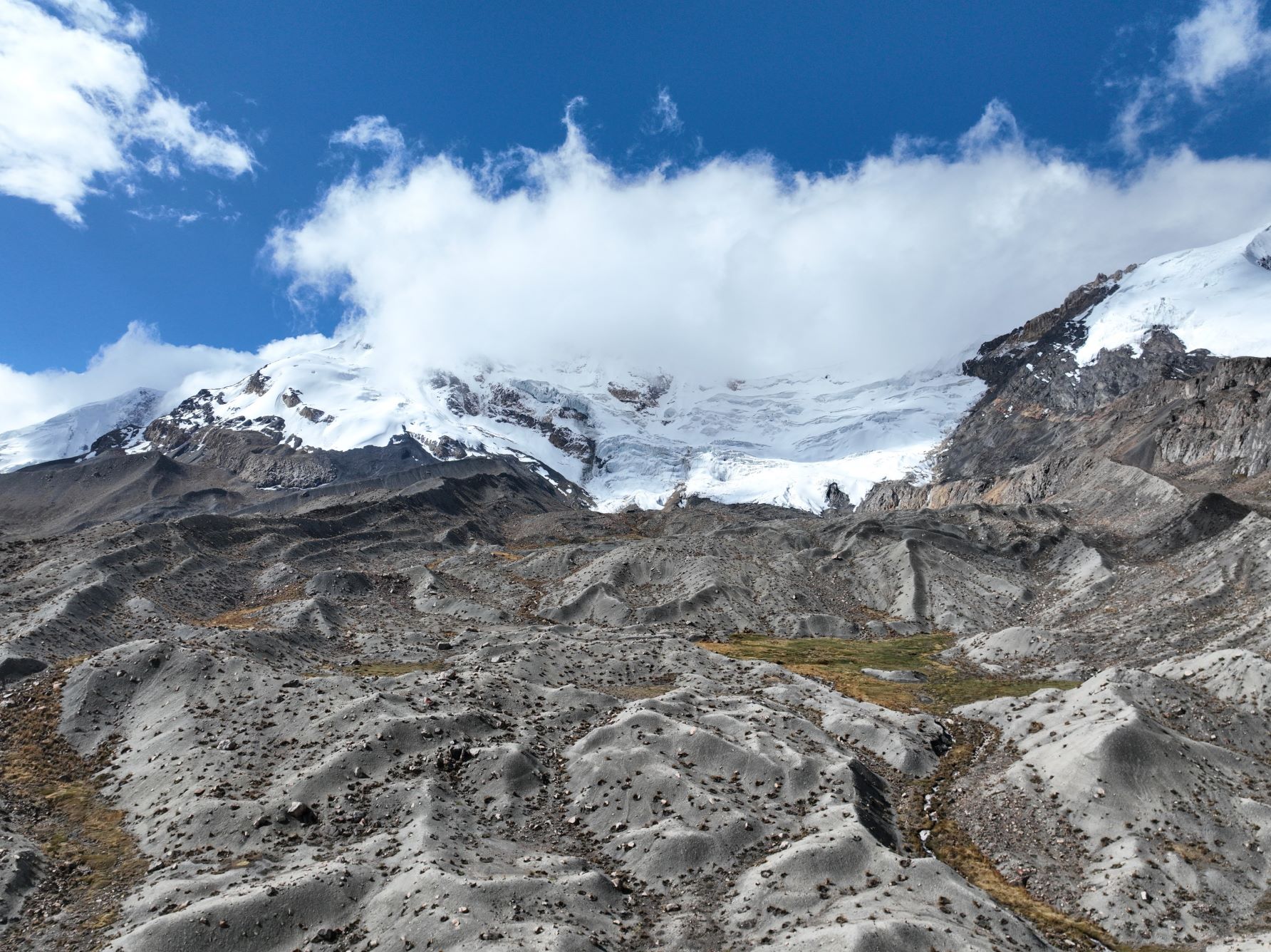
- Description (Physical–Ecological–Climatic Characteristics): Mountainous landscape with a complex geology and glacial history. Extensive peat deposits in valley bottoms. Glaciers present above c. 5200m.a.sl. Annual precipitation in the Cordillera Vilcanota, between 800 and 1000 mm, is driven largely by advective moisture transport from the nearby Amazon basin (Perry et al., 2017, Drenkhan et al., 2019). Over half the mean annual rainfall falls during the austral summer ‘wet season’ months of December, January and February. Small seasonal temperature range (4.5 – 6.5°C), but a much larger diurnal range with frequent subzero temperatures at night followed by daily maxima in the mid-teens.
- Drainage/River System: Headwater streams drain to the Vilcanota river.
- Site History/Historical Context: The Cordillera is the second largest tropical glaciated mountain range in the world, and the world’s largest tropical glacier, Quelccaya, is located within the basin. Ice core records extracted from Quelcayya since the early 1980s have provided an annually resolved palaeoclimate record for the last 1500 years, and have provided the impetus for modern-day collection of precipitation isotopes and other hydrometric data.
- Glacierized Area: 5.3% (SQC= 16%)
- Main Land Cover(s): Extensive glacial till covering in valley bottoms overlain by peat, shallow poorly developed soils on hillslopes.
- Lithology/Soils: Complex, metamorphic/sedimentary units of the Mitu group.
- Mean Annual Temperature:
- Mean Total Annual Precipitation: 800 mm total
- Snow Characteristics: Ephemeral, usually persisting for no more than a few days even at high elevations.
- Years of Data: Hydrometric monitoring since 2016, meteorological data largely available only since 2018. More intensive data collection / sensor maintenance from start of COPE observation period.
Stations & Observations
Observational Stations and Sites
|
Type |
Station Name |
Latitude |
Longitude |
Elevation |
Notes/Details |
|
Meteorological |
Sibinacocha dam |
13.55197°S |
71.1563°W |
4880 m |
Now maintained by SENAHMI with precip, temp and RH data available online https://www.senamhi.gob.pe/?p=estaciones |
|
Meteorological |
Quisoquipina (SQC) |
13.7944°S |
70.8852°W |
5180 m |
Now maintained by SENAHMI with temp and RH data available online https://www.senamhi.gob.pe/?p=estaciones |
|
Meteorological |
Quelcayya |
13.9197°S |
70.8165°W |
5650 m |
See Fyffe et al, 2021. More recent data may be available on request |
|
Meteorological |
Alayripampa (SQC main wetland) |
13.8772°S |
70.909°W |
4850 m |
Off glacier – tipping bucket rain gauge. |
|
Hydrological |
SQC main outlet |
13.8903°S |
70.9136°W |
4766 m |
Main water level monitoring location in SQC. Original sensor supplemented with other backup installations. |
|
Hydrological |
Quisoquipina glacier (SQC) |
13.806°S |
70.891°W |
5050 m |
Principal glacier in SQC |
|
Shallow groundwater well |
Alayripampa (SQC main wetland) |
13.8772°S |
70.909°W |
4850 m |
A network of x7 shallow wells in the peatland using low-cost ultrasound sensors to record water depth |

Data Availability
Geospatial Data
|
Available Geospatial Data |
Notes (e.g., Source, Resolution, Error/Uncertainty, Date, etc.) |
|
Elevation |
Global DEMs only |
|
Landcover and Soils |
Bofedale map available from INAIGEM https://visor.inaigem.gob.pe/ 1:50K Geological maps (including glacio-fluvial deposits available from INGEMMET) |
|
Stream/River Network |
Global hydrography datasets derived from SRTM available from https://doi.org/10.5194/essd-14-4525-2022 |
Observational Data Availability
-
See Fyffe et al, 2021 for good summary of available glaciological data in the basin https://doi.org/10.1029/2021JD034911
Modelling Activities
Ross, Anthony C., Marc Martinez Mendoza, Fabian Drenkhan, Nilton Montoya, Jan R. Baiker, Jonathan D. Mackay, David M. Hannah, and Wouter Buytaert. "Seasonal water storage and release dynamics of bofedal wetlands in the Central Andes." Hydrological processes 37, no. 8 (2023): e14940. https://doi.org/10.1002/hyp.14940
- This paper describes recent hydrological modelling work in the basin and demonstrates the flexible approach required to make further advances in glacierized tropical areas given data scarcity.
Contact & Further Information
- Thompson, Lonnie G., Ellen Mosley-Thompson, John F. Bolzan, and Bruce R. Koci. "A 1500-year record of tropical precipitation in ice cores from the Quelccaya ice cap, Peru." Science 229, no. 4717 (1985): 971-973. https://doi.org/10.1126/science.229.4717.971
- Fyffe, Catriona L., Emily Potter, Stefan Fugger, Andrew Orr, Simone Fatichi, Edwin Loarte, Katy Medina et al. "The energy and mass balance of Peruvian glaciers." Journal of Geophysical Research: Atmospheres 126, no. 23 (2021): e2021JD034911. https://doi.org/10.1029/2021JD034911
- Perry, L. Baker, Anton Seimon, and Ginger M. Kelly. "Precipitation delivery in the tropical high Andes of southern Peru: new findings and paleoclimatic implications." International journal of Climatology 34, no. 1 (2014): 197-215. https://doi.org/10.1002/joc.3679
Contacts
|
Name |
Role |
Contact Information |
|
Tom Gribbin, British Geological Survey, University of Birmingham and Imperial College London |
PhD researcher |
|
|
Wouter Buytaert, Imperial College London |
Professor & INARCH COPE steering committee member |
|
|
Nilton Montoya |
Professor |
UNSAAC University, Cusco |