Overview
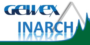
- Location: Alberta, Canada; 51.67°N, 116.55°W
- Website: https://research-groups.usask.ca/hydrology/science/research-facilities/crho.php
- Operational Management: Centre for Hydrology, University of Saskatchewan; Geological Survey of Canada, Natural Resources Canada
- Purpose/Scientific Focus: Peyto Glacier is a long-term reference mass balance glacier, contributing to the World Glacier Monitoring Service (https://wgms.ch/), with records dating from 1965 and other glaciological observations since the nineteeth century. It is the only long-term reference mass balance glacier in the Canadian Rockies. The site has had a long history of scientific research on glacier surface energy and mass exchanges and meteorology, glacier change detection from remote sesning, glacier hydrology, and hydrological model testing and development.
Characteristics
- Location (Physiographic Region): Located in the Park Ranges (Waputik Mountains) of the Canadian Rockies. Peyto Glacier is an outlet glacier on the northern end of the Wapta Icefield.
- Area: 23.6 km2
- Elevation: Min. 1,951 m a.s.l. to Max. 3,180 m a.s.l.
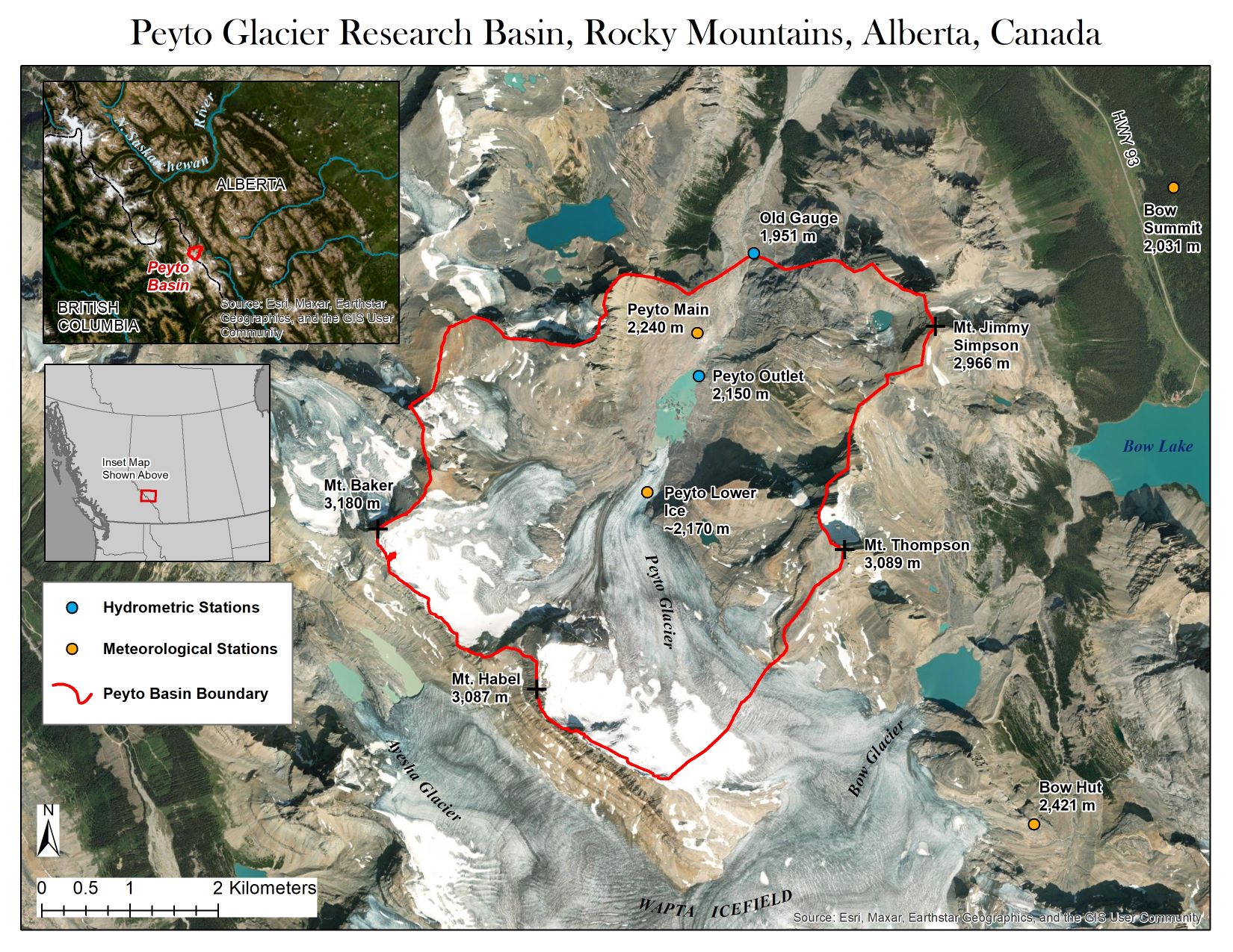
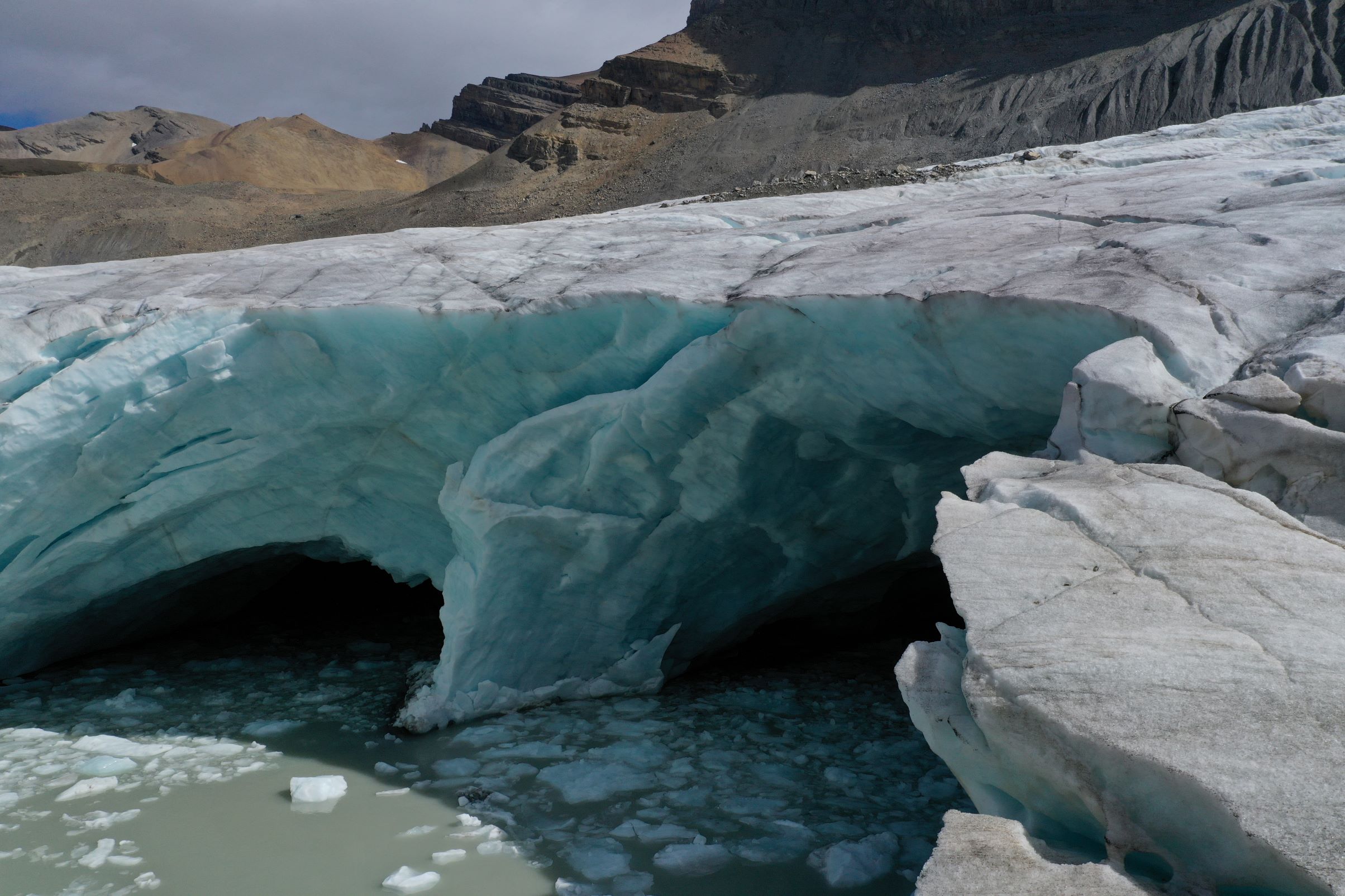
- Description (Physical–Ecological–Climatic Characteristics): The basin is a high relief headwater basin along the continetal divide of North America with significant glacier cover. Peyto Glacier has been losing mass and retreating since at least the 1920s, but in recent years it has undergone a considerable acceleration of shrinkage. A proglacial lake ("Lake Munroe") formed at the terminus in the last decade, and continues to grow larger as the glacier retreats.
- Drainage/River System: Peyto Glacier contributes runoff to the Mistaya River basin, a headwater of the North Saskatchewan River, which eventually reaches Hudson Bay via the Nelson River.
- Site History/Historical Context: The first geophysical record of Peyto Glacier goes back to a photograph taken by Walter D. Wilcox in 1896, followed by subsequent photographs and a map from the Alberta-British Columbia Interprovincial Boundary Commission Survey. Significant research on the glacier began in 1965, when it was selected as one of the research sites for the International Hydrological Decade (IHD). The scope and observational resources have varied since then, with more recent advances and restoration of observations. See https://doi.org/10.5194/essd-13-2875-2021 for further details.
- Glacierized Area (% and year(s) measured):
- Main Land Cover(s): The basin is mostly barren alpine (rock, alpine grasses/shrubs, small lakes and tarns) with signifiant glacier cover.
- Lithology/Soils: Predominantly sedimentary geological region, with surrounding mountains formed from hard, resistant dolomite.
- Mean Annual Temperature:
- Mean Total Annual Precipitation:
- Snow Characteristics:
- Years of Data: Data are avaialble since 1965
Stations & Observations
Observational Stations and Sites
| Type | Station Name | Latitude | Longitude | Elevation | Notes/Details |
| Meteorological | Peyto Main | 51.68549°N | 116.54495°W | 2240 m | July 2013 to present |
| Meteorological | Peyto Lower Ice | 51.67669°N | 116.53399°W | 2173-2183 m | Aug 1995 to present |
| Meteorological | Bow Hut | 51.63517°N | 116.49031°W | 2421 m | Oct 2012 to present |
| Meteorological | Bow Summit | 51.7000°N | 116.4667°W | 2031 m | Bow Summit data can be downloaded from Alberta Climate Information Service (http://agriculture.alberta.ca/acis/) |
| Hydrometric | Peyto Outlet | 51.68111°N | 116.54472°W | 2150 m | Jun 2013 to present |
| Hydrometric | Old gauge: Peyto Creek at Peyto Glacier | 51.69361°N | 116.53556°W | 1951 m | Water Survey of Canada gauge 05DA008; 1967 to 1977 |
|
Notes Historical data at other stations are available since 1965. See https://doi.org/10.5194/essd-13-2875-2021 for a detailed description of all stations/sensors available and the respective data repositories. |
|||||
Field Observation Campaigns and Other Measurements
| Measurement | Instrument Description | Spatial/Temporal Resolution and Coverage | Notes/Details |
| Terrestrial Laser Scanner | |||
| UAV Sensors | Once a year (late august) with eBeeX (multispectral/thermal/RGB) or AltaX (lidar/RGB/thermal/multispectral) | ||
| Time-lapse Photographs | |||
| Snow Pits/Snow Surveys | Yes, infrequent manual snow surveys on ice and moraine, once a year usually | ||
| Glacier Surface Elevation | |||
| Glacier Mass Balance | |||
|
Notes See |
|||
Data Availability
Geospatial Data
| Elevation | Yes, 10 m photogrammetric DEM, 10 m and 1 m Lidar DEMs, and higher resolution from UAV-lidar on tongue since 2019 |
| Landcover and Soils | Several landcover classifications based on Landsat images from 1966 to 2018 |
| Stream/River Network | |
| Basin Delineation/Shapefile |
Observational Data Availability
- Historical data avaialble via https://doi.org/10.5194/essd-13-2875-2021
- Realtime meteorological data via http://giws.usask.ca/cfh/GOES/peytochart.html
- Glacier mass balance data can be found at https://wgms.ch/
Modelling Activities
See
- Aubry‐Wake, C., Pradhananga, D., & Pomeroy, J. W. (2022). Hydrological process controls on streamflow variability in a glacierized headwater basin. Hydrological Processes, 36(10), e14731. https://doi.org/10.1002/hyp.14731
- Pradhananga, D., & Pomeroy, J. W. (2022). Diagnosing changes in glacier hydrology from physical principles using a hydrological model with snow redistribution, sublimation, firnification and energy balance ablation algorithms. Journal of Hydrology, 608, 127545. https://doi.org/10.1016/j.jhydrol.2022.127545
- Pradhananga, D., & Pomeroy, J. W. (2022). Recent hydrological response of glaciers in the Canadian Rockies to changing climate and glacier configuration. Hydrology and Earth System Sciences, 26(10), 2605-2616. https://doi.org/10.5194/hess-26-2605-2022
Contact & Further Information
Additional Information
- The book, Peyto Glacier: One Century of Science, provides a useful summary of the history and science at Peyto Glacier.
- The canary in the icefield, CBC News, Sept 5 2023, https://www.cbc.ca/newsinteractives/features/the-canary-in-the-icefield
- Dr. John Pomeroy, Centre for Hydrology, University of Saskatchewan (john.pomeroy@usask.ca)