Overview
- Location: Andalucia, Spain; 36.98°N, 3.30°W
- Operational Management: Fluvial Dynamics and Hydrology Research Group, University of Cordoba
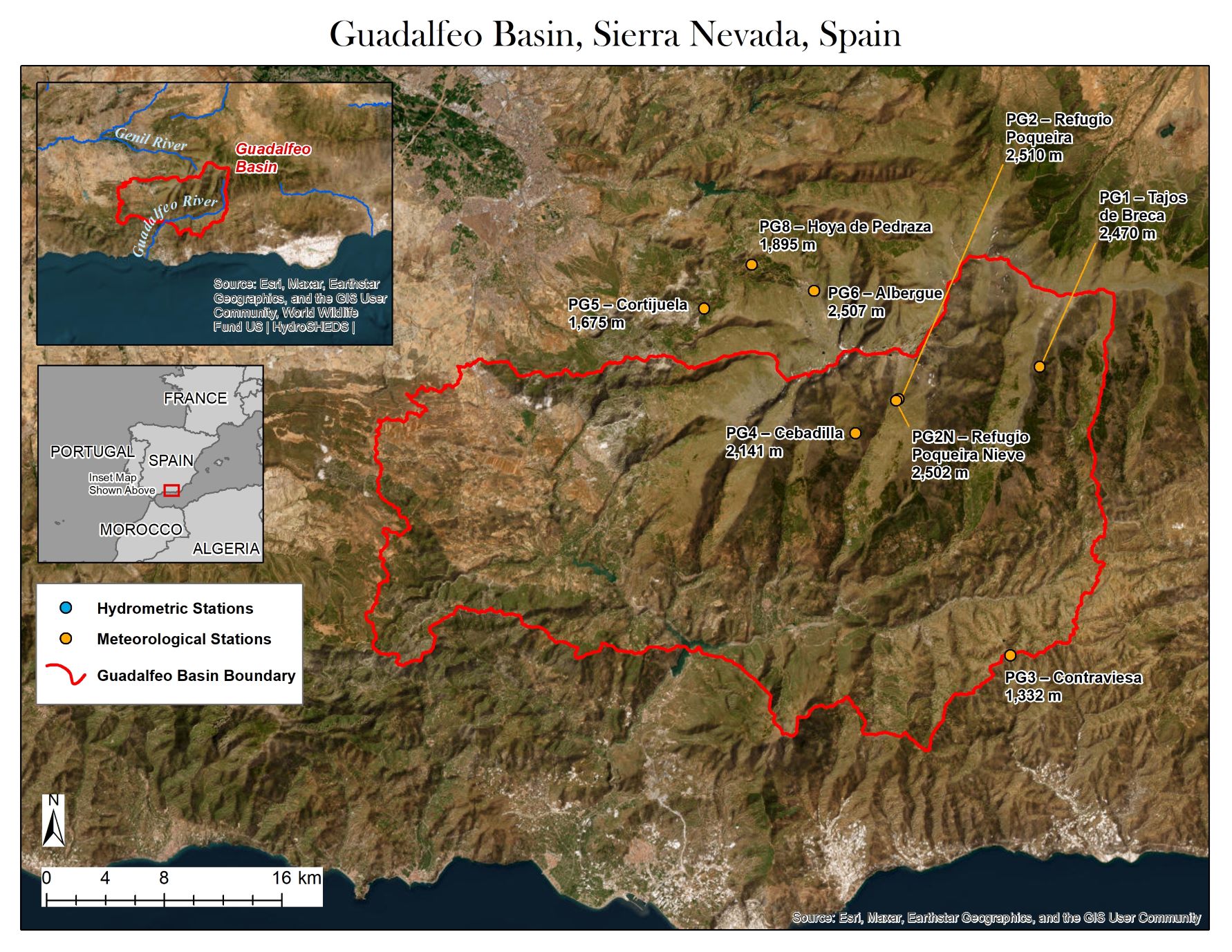
- Purpose/Scientific Focus: The Guadalfeo Monitoring Network (GMN) is located on the Sierra Nevada Mountain Range (Southern, Spain), a linear 80 km range, with about 40 km width, parallel to the shoreline of the Mediterranean Sea. Headwater catchments within the range are representative of Mediterranean mountain basins. That is, small to medium size mountain-coastal basins with high elevation gradients, where Alpine climate can be found in higher latitudes and Mediterranean climate in the lower ones. The monitoring network was settled with a twofold aim: to fill the gap in the distribution of meteorological information above 1000 m a.s.l. in the area and, consequently, to be able to better understand snow dynamics over these types of environments. The weather stations that compose the network have been sequentially installed since 2004. Currently, 7 sites composed the network. The first 4 are located in the headwaters of the Guadalfeo River Basin, in the southern face of the range and the last 3 belong to the headwaters of the Genil River Basin in the north face of the range.
Characteristics
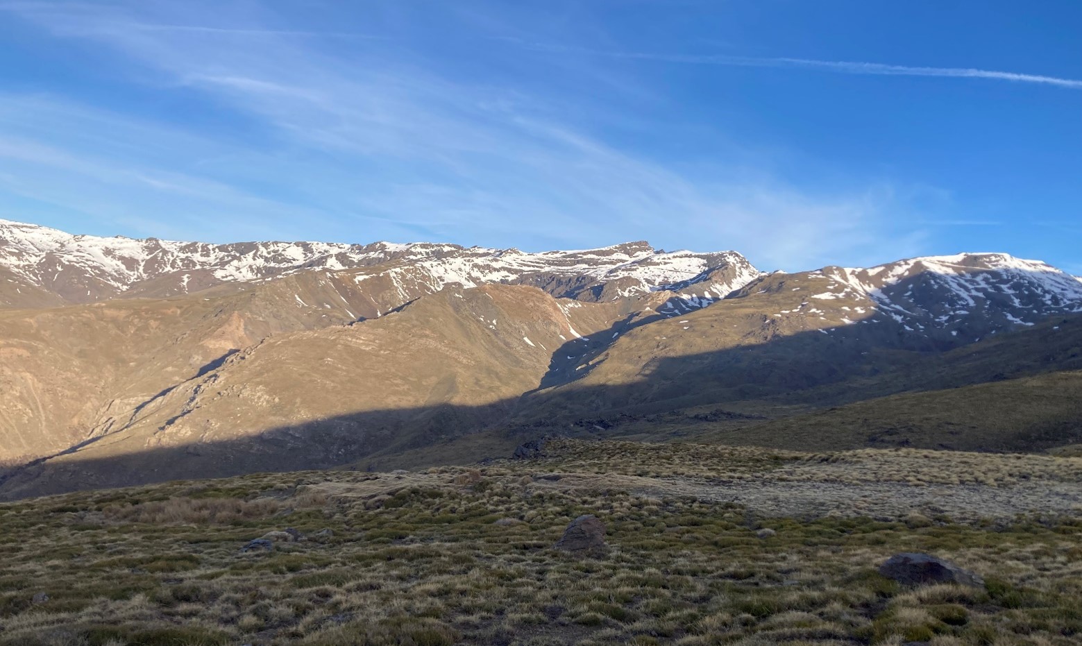
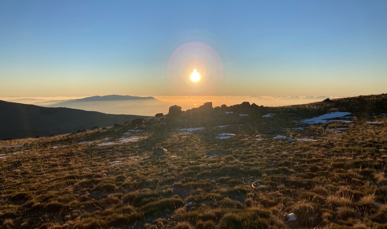
- Location (Physiographic Region): The GMN is situated in the Sierra Nevada Mountain Range within the Mediterranean Biogeographical Region of Europe. In the range snow presence is seasonal above 2000 m.a.s.l. from November to May.
- Area: Guadalfeo River Basin: 1058 km2; Genil River Basin: 938 km2
- Elevation: Guadalfeo River Basin: Mean: 1418 m; Max: 3479 m; Min: 300 m | Genil River Basin: Mean: 1270 m; Max: 3479 m; Min: 655 m
- Description (Physical–Ecological–Climatic Characteristics): The GMN covers a mountain landscape compose by a complex geology mades up of thick layers of graphite schists and mica schists forming the the Nevado-Filábride complex, which constitutes the main geological unit of the Baetic. It is also a hotspot of biodiversity in the Western Mediterranean, being declared UNESCO Biosphere Reserve in 1986, Natural Park in 1989 and National Park in 1999. Alpine climate can be found in higher latitudes and Mediterranean climate in the lower ones, with presence of seasonal snow in elevations above 2000 m.
- Drainage/River System: GMN covers two headwater catchments: the Guadalfeo River Basin, in the southern face, which drains to the Mediterranean Sea; and the Genil River Basin, which flow into the Guadalquivir River, being its main tributary.
- Site History/Historical Context: The Guadalfeo Monitoring Network (GMN) is the extension of the initial weather station at Refugio Poqueira in 2004 within the framework of the Guadalfeo Project (Andalusian Regional Government), coordinated by Miguel A. Losada from the Andalusian Institute for Earth System Research at the University of Granada, whose continuous support and inspiration made the creation of the Fluvial Dynamics and Hydrology research group in 2009 possible, which has been responsible for the GMN ever since.
- Main Land Cover(s): Pasture, low creeping vegetation and shrubs are the main land covers at high elevation. Trees are not common, just isolated plots of reforested pine trees and some spots of oak trees are found at medium elevation. Traditional agriculture plots are present in the lower parts of the area.
- Lithology/Soils: The lithological succession in the western part of Sierra Nevada is formed by the Alpujarride complex, which is composed, in turn, by phyllites in the lower parts and to a lesser extent by quartzites that can reach a thickness of several hundreds of meters. Above them, a thick carbonate series of marbles. The upper units are composed by schists. Soils are shallow, especially in the upper part of the range.
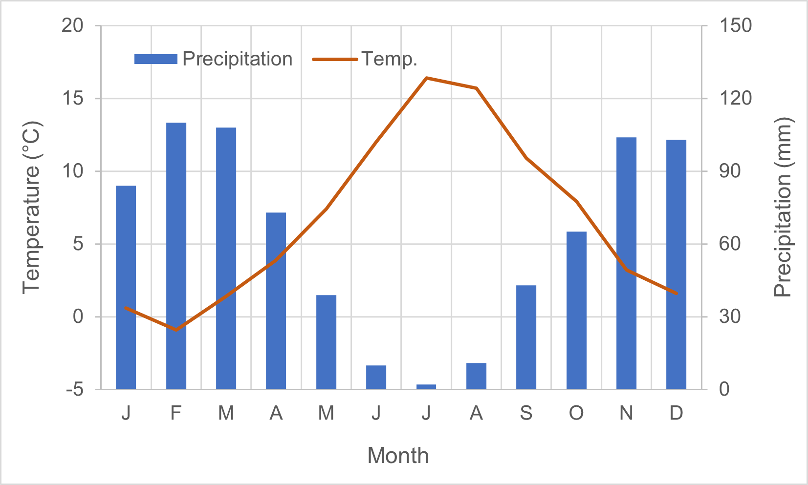
- Mean Annual Temperature: 6.7°C
- Mean Total Annual Precipitation: 752
- Snow Characteristics: Snow has a marked seasonal character being present above 2000 m a.s.l. from November to May. The mild winter temperatures in combination with the high long dry sunny period undergo in: (i) a highly variable snowpack, in time and space, with the presence of several accumulation and melting cycles during the snow season; (ii) a shallow snowpacks with a characteristic patchy distribution; (iii) a high snowpack density; and (iv) a non-negligible evaposublimation losses from the snowpack to the atmosphere. High mountain hydrology is determined by the local dynamics of snow, which covers the soil surface and partially or totally the vegetation cover, decreases infiltration rates and direct runoff from precipitation during the cold periods but enhances infiltration volumes and aquifer recharge during melting periods, delays the water delivery to the fluvial network, and increases spring and summer river flows and soil moisture, extending the flow season in ephemeral rivers.
- Years of Data: 2004 – present
Stations & Observations
Observational Stations and Sites
|
Type |
Station Name |
Latitude |
Longitude |
Elevation |
Notes/Details |
|
Meteorological |
PG1 – Tajos de Breca |
37.048 |
-3.215 |
2470 |
Belongs to the Guadalfeo River Basin (southern face of Sierra Nevada) |
|
Meteorological |
PG2 – Refugio Poqueira |
37.028 |
-3.323 |
2510 |
Belongs to the Guadalfeo River Basin (southern face of Sierra Nevada) |
|
Snow |
PG2N – Refugio Poqueira Nieve |
37.027 |
-3.325 |
2502 |
Belongs to the Guadalfeo River Basin (southern face of Sierra Nevada) |
|
Meteorological |
PG3 – Contraviesa |
36.871 |
-3.237 |
1332 |
Belongs to the Guadalfeo River Basin (southern face of Sierra Nevada) |
|
Meteorological |
PG4 – Cebadilla |
37.007 |
-3.356 |
2141 |
Belongs to the Guadalfeo River Basin (southern face of Sierra Nevada) |
|
Meteorological |
PG5 – Cortijuela |
37.083 |
-3.472 |
1675 |
Belongs to the Genil River Basin (northern face of Sierra Nevada) |
|
Meteorological |
PG6 – Albergue |
37.094 |
-3.388 |
2507 |
Belongs to the Genil River Basin (northern face of Sierra Nevada) |
|
Meteorological |
PG8 – Hoya de Pedraza |
37.110 |
-3.436 |
1895 |
Belongs to the Genil River Basin (northern face of Sierra Nevada) |
Field Observation Campaigns and Other Measurements
|
Measurement |
Station |
Instrumentation Description |
Height/ Depth (m) |
Spatial/Temporal Resolution and Coverage |
|
|
Time-lapse Photographs |
PG2 |
CC640 |
3.5 m |
5 image per day every 2 hours (8:00-16:00) |
|
|
|
PG2N |
CC5MPX |
2.5 m |
Aug 2021 – present / 8 image per day every 2 hours (6:00 – 20:00) |
|
|
|
PG6 |
CCFC |
2 m |
Aug 2021 – present / 8 image per day every 2 hours (6:00 – 20:00) |
|
|
|
PG8 |
CC5MPX |
2.2 m |
Jul 2020 – Jun 2022 / 8 image per day every 2 hours (6:00 – 20:00) |
|
Data Availability
Geospatial Data
|
Available Geospatial Data |
Notes (e.g., Source, Resolution, Error/Uncertainty, Date, etc.) |
|
Elevation |
Digital elevation model (DEM) with 5 m resolution— raster available from the Spanish Geographical Institute (IGN) for the whole country https://www.idee.es/csw-inspire-idee/srv/spa/catalog.search?#/metadata/spaignMDT05 |
|
Landcover and Soils |
Landcover types — raster available from the Regional Environmental Information Network (REDIAM) for the whole region http://www.ideandalucia.es/catalogo/inspire/static/api/records/ 8a47da900d8fac2269ddb9e78a06c0dd7d114c63 |
|
Stream/River Network |
Location of the streams, and other water bodies — shapefile available from the Regional Environmental Information Network (REDIAM) for the whole region http://www.ideandalucia.es/catalogo/inspire/srv/api/records /240fb7357b5fddf1406b802e00c87b49b5a4b365 |
|
Basin Delineation/Shapefile |
Location of the catchments boundaries — shapefile available from the Regional Environmental Information Network (REDIAM) for the whole region http://www.ideandalucia.es/catalogo/inspire/srv/api/records /240fb7357b5fddf1406b802e00c87b49b5a4b365 |
Observational Data Availability
- Polo, M. J., Herrero, J., Pimentel, R., and Pérez-Palazón, M. J.: The Guadalfeo Monitoring Network (Sierra Nevada, Spain): 14 years of measurements to understand the complexity of snow dynamics in semiarid regions, Earth Syst. Sci. Data, 11, 393–407, https://doi.org/10.5194/essd-11-393-2019, 2019.
Modelling Activities
Contact & Further Information
Additional Information
- Aguilar C, Pimentel R, Polo MJ (2021) Two decades of distributed global radiation time series across a mountainous semiarid area (Sierra Nevada, Spain). Earth Syst Sci Data 13:1335–1359. https://doi.org/10.5194/essd-13-1335-2021
- Herrero J, Polo MJ (2012) Parameterization of atmospheric longwave emissivity in a mountainous site for all sky conditions. Hydrol Earth Syst Sci 16:3139–3147. https://doi.org/10.5194/hess-16-3139-2012
- Herrero J, Polo MJ (2016) Evaposublimation from the snow in the Mediterranean mountains of Sierra Nevada (Spain). Cryosph 10:2981–2998. https://doi.org/10.5194/tc-10-2981-2016
- Herrero J, Polo MJ, Moñino A, Losada MA (2009) An energy balance snowmelt model in a Mediterranean site. J Hydrol 371:98–107. https://doi.org/10.1016/j.jhydrol.2009.03.021
- Pérez-Palazón MJ, Pimentel R, Polo MJ et al (2018) Climate trends impact on the snowfall regime in Mediterranean mountain areas: future scenario assessment in Sierra Nevada (Spain). Water 10:720. https://doi.org/10.3390/w10060720
- Pimentel R, Herrero J, Polo MJ (2017a) Subgrid parameterization of snow distribution at a Mediterranean site using terrestrial photography. Hydrol Earth Syst Sci 21:805–820. https://doi.org/10.5194/hess-21-805-2017
- Pimentel R, Herrero J, Polo MJ (2017b) Quantifying snow cover distribution in semiarid regions combining satellite and terrestrial imagery. Remote Sens 9:995. https://doi.org/10.3390/rs9100995
- Polo M, Herrero J, Aguilar C et al (2009) WiMMed, a distributed physically-based watershed model (I). Environ Hydraul Theor Exp Comput Solut 225–228, link to pdf
- Polo MJ, Herrero J, Pimentel R, Pérez-Palazón MJ (2019) The Guadalfeo Monitoring Network (Sierra Nevada, Spain): 14 years of measurements to understand the complexity of snow dynamics in semiarid regions. Earth Syst Sci Data. https://doi.org/10.5194/essd-11-393-2019
Contacts
|
Name |
Role |
Contact Information |
|
Dr. Rafael Pimentel |
Assistant Professor. University of Cordoba |
Email: rpimentel@uco.es Phone: +34 957 212662 |
|
Dr. Ana Andreu |
Postdoctoral Researcher. University of Cordoba |
Email: ana.andreu@uco.es Phone: +34 957 212662 |
|
Dr. María José Polo |
Professor and head of Fluvial Dynamics and Hydrology Research Group. University of Cordoba |
Email: ana.andreu@uco.es Phone: +34 957 212662 |