
Overview

- Location: Russia; 43.21°N, 42.74°E
- Operational Management: Lomonosov Moscow State University; Water problems institute Russian Academy of Sciences
- Purpose/Scientific Focus: The Djankuat Glacier was chosen as representative of the central North Caucasus during the International Hydrological Decade (IHD) - research program on water problems launched by UNESCO in 1965 - and is one of 30 ‘reference’ glaciers in the world which has annual mass balance series longer than 50 years. The mass-balance measurements have been carried out on Djankuat glacier since 1967 till now regularly (www.wgms.ch) based on standard methods. Detailed hydrological and meteorological measurements were included in the monitoring program of the station during the IHD and came to an end in the late 1970s. The comprehensive hydrometeorological observation was resumed in the Djankuat research basin since 2007. Hydrometeorological measurements were done during the ablation season every year since 2007, all-year round hydrological gauge since 2021, and the observational program gradually expanded during 2007–2023 and now goes beyond the standard network hydrological and meteorological observations.
Characteristics
- Location (Physiographic Region): Alpine zone of the North Caucasus.
- Area: 12.4 km2
- Elevation: 2600 - 4000 m
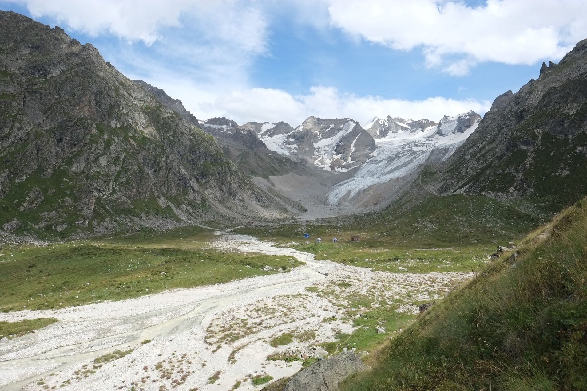
- Description (Physical–Ecological–Climatic Characteristics): The Djankuat research basin is situated on the northern slope of the central part of the Main Caucasian Ridge. The climate is moderate continental to high-alpine.
- Drainage/River System: The Djankuat River is a source of the Adul-Su River – a tributary of the Baksan River which drains into the Caspian Sea via the Terek River.
- Site History/Historical Context: The Djankuat glacier was chosen as representative of the central North Caucasus during the International Hydrological Decade (IHD) - research program on water problems launched by UNESCO in 1965 - and is one of 30 ‘reference’ glaciers in the world which has annual mass balance series longer than 50 years.
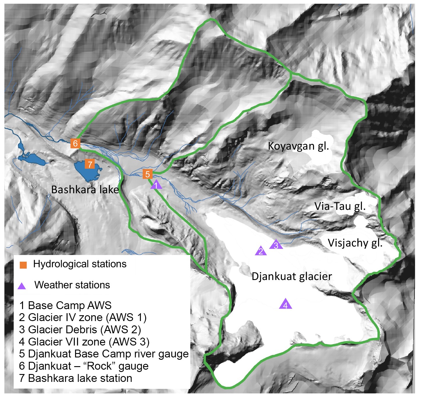
- Glacierized Area (% and year(s) measured): In 2017 glaciers occupied 27% of the territory of the basin. The main glacier with the same name – Djankuat Glacier – is the source of the Djankuat River. It is a valley glacier, with the lowest point of the tongue at approximately 2750 m, the elevation of the bergschrund is at 3600 m. The mean elevation of the glacier is 3210 m, the area is 2.42 km2, and its length is 3.0 km. The maximum measured thickness of the glacier is 105 m, and the average thickness is 31 m. The Djankuat River basin also contains three small glaciers with areas less than 0.5 km2: Koyavgan, Via-Tau, and Visyachiy.
- Main Land Cover(s): Alpine highlands with steep slopes and a wide development of coarse-grained deposits, with numerous outcrops of exposed rocks, with alpine lawns in the lower part of the basin and with glacial-nival landscapes in its middle and upper parts.
- Lithology/Soils: Crystalline schists and gneisses; gravelly shallow humus soils.
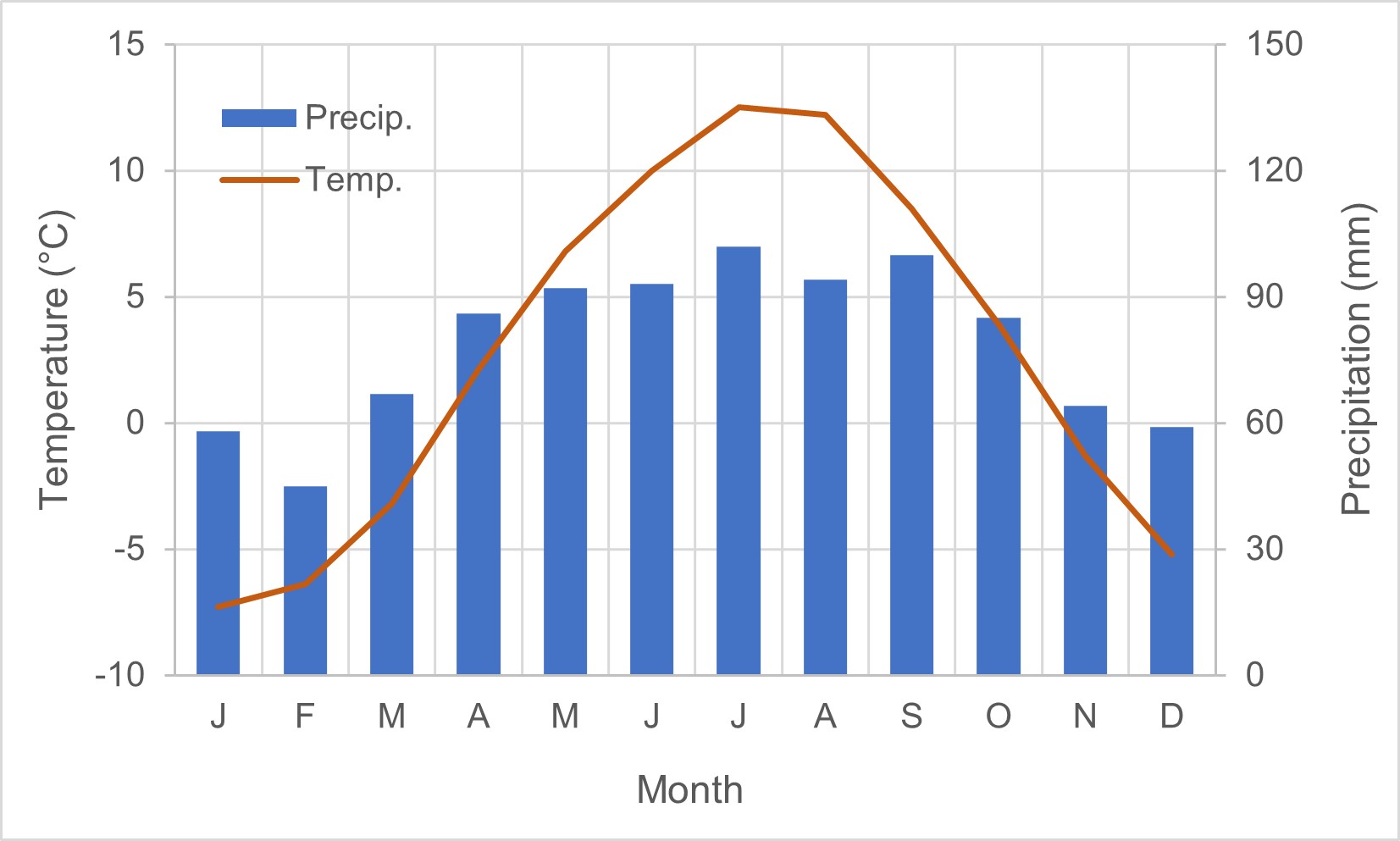
- Mean Annual Temperature: 2.7°C
- Mean Total Annual Precipitation: 942
- Snow Characteristics: Stable snow cover is generally observed on the whole basin area from October-November to May. In the accumulation zone of glaciers snow persists through the year. Mean measured snowdepth on the Djankuat Glacier is 3600 mm, Maximum is 11550 mm.
- Years of Data: (1970s) – 2007 – ongoing
Stations & Observations
Observational Stations and Sites
| Type | Station Name | Latitude | Longitude | Elevation | Notes/Details |
| Meteorological | Djankuat Base Camp AWS | 43.208°N | 42.736°E | 2640 m | |
| Meteorological | Djankuat Glacier AWS 1 | 43.198°N | 42.757°E | 3000 m | IV zone of the Djankuat glacier on the ice surface |
| Meteorological | Djankuat Glacier AWS 2 | 43.200°N | 42.759°E | 3050 m | IV zone of the Djankuat glacier on the debris covered ice |
| Meteorological | Djankuat Glacier AWS 3 | 43.193°N | 42.759°E | 3200 m | |
| Hydrometric | Djankuat River Base Camp Gauging Station | 43.209°N | 42.736°E | 2630 m | |
| Hydrometric | Djankuat River Rock Gauging Station | 43.213°N | 42.725°E | 2600 m |
Field Observation Campaigns and Other Measurements
| Measurement | Instrument Description | Spatial/Temporal Resolution and Coverage | Notes/Details |
| Glacier Ice Thickness |
radio-echo sounding and modelling |
2012-2013 | Lavrentiev I.I., Kutuzov S.S., Petrakov D.A., Popov G.A., Popovnin V.V. Ice thickness, volume and subglacial relief of Djankuat Glacier (Central Caucasus). Ice and Snow. 2014;54(4):7-19. https://doi.org/10.15356/2076-6734-2014-4-7-19 |

Glacier/snow ablation is measured at 35–45 evenly distributed points on the Djankuat Glacier surface, 2007–ongoing, with 1-30 days timestep.
Data Availability
Geospatial Data
| Elevation | available on request |
| Landcover and Soils | Aleynikova, A. M. Struktura i dinamika prilednikovykh landshaftov Priel'brus'ya / A. M. Aleynikova, M. N. Petrushina // Lod i sneg. – 2011. – № 2(114). – S. 127-134. – EDN PJEMMH. (in Russian) |
| Stream/River Network | available on request |
| Basin Delineation/Shapefile | available on request |
Observational Data Availability
- Rets, E. P., Popovnin, V. V., Toropov, P. A., Smirnov, A. M., Tokarev, I. V., Chizhova, J. N., Budantseva N. A. et al. 2019 Djankuat glacier station in the North Caucasus, Russia: a database of glaciological, hydrological, and meteorological observations and stable isotope sampling results during 2007–2017. Earth System Science Data 11, 3, 1463-1481. https://doi.org/10.5194/essd-11-1463-2019
- Rets, EP; Popovnin, VV; Toropov, PA et al. (2022): Hydrological, meteorological observations and isotopes sampling results during 2019-2020 at Djankuat Glacier Station in the North Caucasus, Russia. https://doi.org/10.1594/PANGAEA.940839
Modelling Activities
- Rets, E., Fomichev, S. and Belozerov, E., 2021, April. Testing different machine learning techniques for runoff routing in a highly glacierized Djankuat river basin (the North Caucasus, Russia). In EGU General Assembly Conference Abstracts (pp. EGU21-4567). https://ui.adsabs.harvard.edu/abs/2021EGUGA..23.4567R/abstract
- Belozerov, E., Rets, E., Petrakov, D. and Popovnin, V., 2020. Modelling glaciers’ melting in Central Caucasus (the Djankuat and Bashkara Glacier case study). In E3S Web of Conferences (Vol. 163, p. 01002). EDP Sciences. https://www.e3s-conferences.org/articles/e3sconf/abs/2020/23/e3sconf_vc2020_01002/e3sconf_vc2020_01002.html
- Verhaegen, Y., Huybrechts, P., Rybak, O. and Popovnin, V.V., 2020. Modelling the evolution of Djankuat Glacier, North Caucasus, from 1752 until 2100 CE. The Cryosphere, 14(11), pp.4039-4061. https://doi.org/10.5194/tc-14-4039-2020
Contact & Further Information
Additional Information
- Rets, E.P., Popovnin, V.V., Toropov, P.A., Smirnov, A.M., Tokarev, I.V., Chizhova, J.N., Budantseva, N.A., Vasil'chuk, Y.K., Kireeva, M.B., Ekaykin, A.A. and Veres, A.N., 2019. Djankuat glacier station in the North Caucasus, Russia: A database of glaciological, hydrological, and meteorological observations and stable isotope sampling results during 2007–2017. Earth System Science Data, 11(3), pp.1463-1481. https://doi.org/10.5194/essd-11-1463-2019
- Popovnin, V.V., Rezepkin, A.A. and Tielidze, L.G., 2015. Superficial moraine expansion on the Djankuat Glacier snout over the direct glaciological monitoring period. Earth Cryosphere, 19(1), pp.79-87.
- Verhaegen, Y., Huybrechts, P., Rybak, O. and Popovnin, V.V., 2020. Modelling the evolution of Djankuat Glacier, North Caucasus, from 1752 until 2100 CE. The Cryosphere, 14(11), pp.4039-4061. https://doi.org/10.5194/tc-14-4039-2020
- Tsyplenkov, A., Vanmaercke, M., Collins, A.L., Kharchenko, S. and Golosov, V., 2021. Elucidating suspended sediment dynamics in a glacierized catchment after an exceptional erosion event: The Djankuat catchment, Caucasus Mountains, Russia. Catena, 203, p.105285. https://doi.org/10.1016/j.catena.2021.105285
- Verhaegen, Y., Rybak, O., Popovnin, V. and Huybrechts, P., 2023. Quantifying supraglacial debris-related melt-altering effects on the Djankuat Glacier, Russian Federation, Part 1: comparison of surface energy and mass fluxes over clean and debris-covered ice. https://essopenarchive.org/doi/full/10.22541/essoar.167810334.49773219
- Popovnin V.V., Pylayeva T.V. Avalanche feeding of the Djankuat Glacier. Ice and Snow. 2015;55(2):21-32. https://doi.org/10.15356/2076-6734-2015-2-21-32
- Dr. Ekaterina Rets (ekaterina.p.rets@gmail.com)
- Dr. Viktor Popovnin (begemotina@hotmail.com)